
1897 La Plata Colorado Historical Rare Antique Original USGS Topo Map Menefee Mountain WSA San Juan store NF 15-minute Topological
This antique sheet is an 1897 edition of the La Plata Colorado USGS topographic map. It is an authentic 122-year-old United States Geological Survey print in good condition.
HOW THIS MAP CAN BE USED
In addition to making a fascinating conversation piece, this sheet would look great in a frame or on display, make a unique and prized gift for anyone interested in this area, be perfect as a reference for genealogy studies or general historical research, or fill that missing piece in your collection.
* Title-> La Plata
* State-> Colorado
* Edition-> 1897
* Engraved-> 1896
* Printed-> 1897, thick paper stock
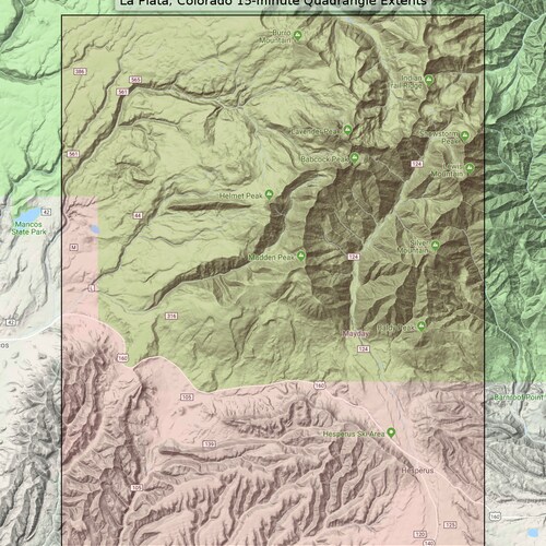
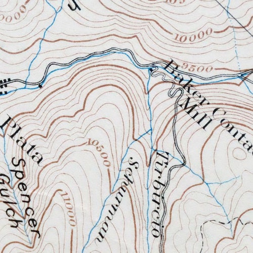
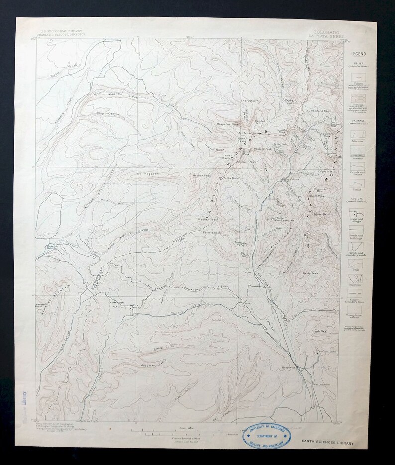
FEATURES SHOWN ON THE MAP
The La Plata 15-minute map shows cities and towns store, roads, railroads, rivers, creeks, elevation contour lines, public land survey lines, county, state, and other administrative boundaries as they existed at the time of the survey in 1895. All known structures (houses, businesses, churches, schools, barns, cabins, etc) are also shown, with exceptions in some urban areas, where only landmark buildings may be shown.
* Series-> 15-minute
* Scale-> 1:62500
* Contour Interval-> 100 Foot
SURVEYING AND CARTOGRAPHY
The La Plata map was field surveyed before aerial photography methods were widely used in map data gathering. It was drawn by skilled cartographers at the United States Geological Survey based on plane table field survey information as well as information gathered from local residents in the area. This piece displays the remarkable abilities of early government map makers, who placed a strong emphasis on creating complete, accurate, and cartographically appealing maps.
* Surveyed-> 1895 Field Survey
* Geographer-> Henry Gannett
A VALUABLE HISTORICAL RECORD
Maps from the 15-minute series for the continental United States are no longer produced or printed by the USGS and original prints are becoming increasingly difficult to find. They are a valuable historical record for an area, as they contain many placenames and features that have been dropped from more recent maps.
* Sheet Dimensions-> 16 1/2 x 20 inches (approximate)
* Map Dimensions-> 13 7/8 x 17 1/2 inches
* Map Coverage-> 14 x 17 miles
SHEET CONDITION: Good
* Sheet Notes-> moderately handled, never folded, lightly age-toned sheet
* Map Area-> no wear, no markings, no blemishes
* Collar Area-> minor wear, no markings, very minor blemishes, inventory stamp on lower collar
PLACENAMES
The following places are found within the boundary of this quadrangle. They may or may not be shown or labeled, depending on the map series and vintage.
* Cities and Towns-> Mayday and Hesperus
* Counties Covered-> La Plata and Montezuma
* Federal Land Units-> San Juan National Forest and Menefee Mountain Wilderness Study Area
* Rivers and Streams-> West Mancos River, Turkey Creek, Tirbircio Creek, Starvation Creek, Spring Creek, South Fork West Mancos River, South Fork Lightner Creek, South Fork Hermosa Creek, Silver Creek, North Fork West Mancos River, and others
* Water Bodies-> Weber Reservoir